The birth of Woodstock
The history of Woodstock began with the hamlet of Papendorp, a small cluster of thatched buildings, fishermen’s houses and farm cottages, which was situated about two kilometres east of Cape Town, on what became Albert Road. It derived its original name from a local property owner – Pieter van Papendorp, who settled in the area during the mid-eighteenth century. His house, La Belle Alliance, was situated close to Woodstock beach. Gradually other people and their families settled in the surrounding area and by the early 1800s, this collection of buildings had become known as Papendorp. With the increasing English influence after the British Occupation of the Cape, the name was changed to the more Anglicised New Brighton before finally becoming Woodstock.
Farms and estates
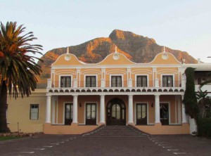
In the beginning of the nineteenth century, when land surveyor and architect Louis Michel Thibault (1750 – 1815) mapped all the properties along the Cape Town to Simon’s Town road (now Main Road), numerous farms and estates had sprung up. On the slopes of Devil’s Peak, overlooking Table Bay, was Zonnebloem (now Zonnebloem College); travelling further into Woodstock, also on the mountain slopes, was Leliebloem on the right (also known as Leliefontein – there was a mountain spring on the estate – hence the name meaning ‘Lily fountain/spring’). Both Leliebloem and neighbouring Roodebloem were granted as freehold farms in 1692. The Roodebloem farmhouse later became home to the well-known Ruth Prowse School of Art (ruthprowse.co.za) in 1970, named after the famous artist (1883 – 1967) who lived there in an outbuilding called The Retreat, which she bequeathed as an art centre.
The Treaty Tree
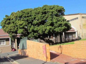
On the sea side of Albert road was Pieter van Papendorp’s homestead, later becoming known as the Treaty House, as the capitulation of the Dutch was signed there under an old milkwood tree on the property. This gnarled tree survives to this day, almost forgotten in a small park on the corner of Spring and Treaty Roads, two small side streets off Albert road. In 1806, when the English sent a fleet of ships to occupy the Cape, after handing it back to the Netherlands in 1803, they reclaimed possession of the province after the Battle of Blaauwberg, where they defeated the Governor, General Janssens. The capitulation of the Dutch was reputedly signed under the Treaty Tree, which was declared a National Monument in 1966. During the dark days of slavery (1658 – 1834), slaves were sold under the tree, while both convicts and slaves were occasionally hanged here too. The historic Treaty House was demolished in the early 20th century to make way for a factory.
Near the Treaty House was another cluster of buildings, part of the farm Altona. The main farmhouse was an attractive gabled homestead that faced the sea. Today, the Altona Hotel, recently converted into a furniture shop, serves as the only reminder of the farm. Moving closer to the Salt River estuary (also reclaimed in the 1950s), the traveller would have encountered the Eberstedt and Haas-en-Koester farms, which became well-known landmarks because of their windmills, both of which have since been demolished.
Woodstock beach
Woodstock beach once stretched along the front part of Woodstock, to the north of the Castle of Good Hope. It was the scene of many shipwrecks during the sailing era, when ships would be blown onto the sand by Cape Town’s notorious gales. One such gale in 1822, called the Great Storm, was commemorated in a detailed (uncredited) watercolour. The scene of devastation on Woodstock beach is impressive, showing numerous wrecked ships and debris scattered all along the beach.
A familiar landmark on Woodstock beach was Fort Knokke, part of a line of defence erected to defend the Cape from attack. A later landmark was the Castle Brewery and the Woodstock pavilion, built for bathers when Woodstock became a popular seaside village in the late nineteenth century. During the massive land reclamation of part of Table Bay to create the Cape Town foreshore in the early 1950s, Woodstock beach was unfortunately destroyed, one of Cape Town’s saddest losses. Beach Road, just in front of the Castle Brewery, and on either side of Lower Church Street, survives as a reminder of where the shoreline was once situated.
Woodstock develops
By the middle of the nineteenth century, the growing suburb of Woodstock had its own Anglican church and a school, and by the 1860s it was known as a fashionable seaside suburb, especially after the new railway line (the first in South Africa) from Cape Town extended there in 1862. The old farms were rapidly subdivided for low-cost housing and the Woodstock suburb began to grow rapidly. During the 1870s its beach front was a favourite bathing spot for Cape Town residents. In 1881, Woodstock, together with the neighbouring village of Salt River became a separate municipality that by 1884 was the third largest ‘town’ in the colony and was completely self-supporting. In 1904 Woodstock was home to almost 30 000 residents, there was also an increase in industrial activity in the area, permanently changing the character of the suburb. During the apartheid era Woodstock managed to stay integrated, with a mix of classes and races living in the same suburb – though neighbouring District Six was demolished and the residents forcibly relocated.
Woodstock and the Springbok
Few people know that German-born artist and lithographer Heinrich Egersdarfer lived for many years in Woodstock, and it was here in the early part of the twentieth century that he designed what was to become the iconic Springbok emblem.
Urban renewal
With the loss of Woodstock beach and the increasingly industrial nature of the suburb, Woodstock lost much of its status and by the late 20th century, many of its lower parts had become run down, with crime and drugs becoming an increasingly serious issue. Slowly though, various media businesses moved into the outskirts of Woodstock, on the Cape Town side. Sir Lowry Road, particularly, was the scene of a lot of urban renewal and clever revamping of old buildings, like the old Castle Brewery for example, to house new offices, shops and furniture showrooms. The redevelopment of the Old Biscuit Mill www.theoldbiscuitmill.co.za (the site of one of the old nineteenth century windmills) for the Neighbourgoods Market recently brought more shops and businesses to the Salt River side of Woodstock, and the revitalisation of Roodebloem Road has led to it becoming a small restaurant area, so, certain pockets of the suburb had become fashionable again. Today, Woodstock’s urban renewal continues, with a variety of new developments taking place and an increase in trendy restaurants and shops moving into the area. Property prices have increased and apartment blocks are springing up. Woodstock, it seems, is back on the map…
Selected sources:
Gabriel and Louise Athiros, The best of Cape Odyssey Volume 1 (Historical Media cc, 2007)
Hans Fransen, The Old Buildings of the Cape (Jonathan Ball Publishers, 2004), C.Pama, Bowler’s Cape Town: Life at the Cape in Early Victorian Times 1834-1868 (Tafelberg Publishers, 1977),Woodstock –- A Selection of articles from The Woodstock Whisperer 2003-2007 Edited by Gabriel and Louise Athiros
Selected web references: www.oldcastlebrewery.co.za, www.travel.igotafrica.com,www.theoldbiscuitmill.co.za
Jim Hislop is the current Senior Copy Editor and Wine Writer for Pick n Pay’s Fresh Living magazine.
A long-time resident of Observatory, he is also a member of the Vernacular Society and is currently researching the history of the old farms of the Observatory and Woodstock area.


April 13th, 2012 at 1:36 pm
SERG-OLIVE Says: Your comment is awaiting moderation.
April 13th, 2012 at 1:23 pm
Hi,
Does anyone know the history of Chamberlain Street in Woodstock?
I was born and raised in Woodstock and witnessed something that is out of the ordinary. This may sound like a ghost story but a true story! When I was about between 5 – 10 years of age during the late 80’s early 90’s. Not sure how I would describe it but “they” seem to appear in the middle of the night where my family is a sleep and hear noises in the kitchen which was located a couple of feet away from my bedroom where I shared with my brothers. They never witnessed anything except for myself and use to think that it was all a dream! However this demon like dark figures (that’s how I would describe them) use to come to my bedroom and watch us sleep and it happened almost in a nightly bases. I could hear them breath deeply and they would disappear in the early hours of the morning. There were occasions that I switched on the bedroom light and it would not switch on. I use to yell out for mother but no sound was coming out of my mouth. Ever since then I believe that there is something out there, whatever it is , it scared the living day lights out of me, and my mom would confirm that I had sleeping problems during the middle of the night and always slept with my bro in he’s bed or sleep in my mom’s room.
Scary hey!!!!!! So if any of you who is reading this or witness anything out of the ordinary in Chamberlain Street, Woodstock please fill me in!
[email protected]
April 15th, 2012 at 9:19 pm
Hi Serge-Olive
This is a typical sleep-paralysis dream and has nothing to do with Woodstock. See this handy article http://www.terrorsofmen.com/136/sleep-paralysis-night-demons. I removed the copies of this comment from the other articles.
July 17th, 2012 at 3:15 pm
It is by coinsidence that i stumble upon this article. It is truly sad that Woodstock has lost its beach and “Grandeur” that it once has and personally i am excited by the proposed urban renewal in the area… All in the name of “vooruitgang”
January 16th, 2013 at 2:38 pm
Does anyone know anything about a farm/large property which was called Langfontein? It was owned by Thomas Willem Hoogendoorn, and he was living there in 1866 when his son Willem Jozua Johannes was baptised. I know that the Hoogendoorn’s bought and sold a lot of property in the Cape Town area.
I am trying to obtain more information on them for my family tree.